


Sant Esteve

Vinceneux
Gebruiker
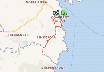

Lengte
5,8 km

Max. hoogte
44 m

Positief hoogteverschil
51 m
Km-Effort
6,5 km

Min. hoogte
2 m

Negatief hoogteverschil
49 m
Boucle
Ja
Datum van aanmaak :
2025-05-19 15:21:18.117
Laatste wijziging :
2025-05-19 16:57:19.821
1h35
Moeilijkheid : Medium

Gratisgps-wandelapplicatie
 SityTrail
IGN / Geografische instituten
SityTrail Plus
De wereld gaat voor u open
Over ons
Tocht Stappen van 5,8 km beschikbaar op Balearen, Onbekend, es Castell. Deze tocht wordt voorgesteld door Vinceneux.
Plaatsbepaling
Land:
Spain
Regio :
Balearen
Departement/Provincie :
Onbekend
Gemeente :
es Castell
Locatie:
Unknown
Vertrek:(Dec)
Vertrek:(UTM)
611527 ; 4413392 (31S) N.
Opmerkingen